Business
Newsday
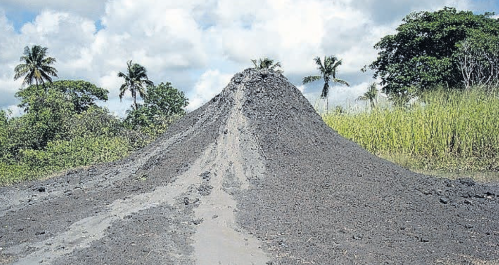
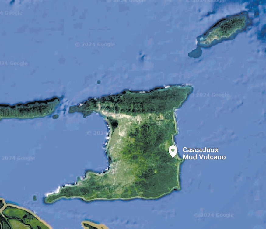
On January 11, at approximately 5 pm, the Cascadoux Mud Volcano at Cascadoux Trace, Mayaro, began erupting.
Residents reported that hot mud was shooting into the air, as high as 15 feet. This ceased later that same night.
Spurts of mud along with gas continued to be released by the two new vents of the mud volcano.
Two of TT’s most prominent geologists, Curtis Archie and Xavier Moonan, made independent visits and investigations into the Cascadoux eruption.
Archie has also been visiting and documenting the site for several years. We have compiled their findings in this article.
Archie’s finding:
To the north of Mayaro, in an area best known for the cultivation of watermelons, there is a hill that rises approximately 90 feet above the southern edge of the Nariva Swamp.
Residents in the area were surprised that the Cascadoux mud volcano had reawakened. There is no recorded history of past eruptions. The activity was confined to a small area where liquid mud being emitted had built a cone about six feet high by 2008. Since then, the release of mud had diminished, and over time, the cone washed away to where we now see a few bumps and one small vent.
Field mapping by geologists of Dominion Oil in 1954 produced a map that had four active vents, which were trended northwest to southeast. George Higgins and John Saunders in 1974 published a brief description of this mud volcano. At that time, the area covered by old mudflows was 50 hectares, and only one mud vent was active.
The large area covered by old mudflows and the height of the hill strongly suggest past eruptions were much larger and more frequent. This low state of activity continued until January 11, when four new areas of mud expulsion appeared.
The lack of activity had lulled villagers into a false sense of security, and some built houses within 70 feet of the pre-2024 vent.
The largest expulsion of mud is near an old vent identified on the 1959 Kugler surface geology map. Mud volcanism in TT extends from Pedernales in Venezuela into the Atlantic off the east coast, and only occurs to the south of the Central Range.
Features associated with mud volcanism range from small vents to large cones and mud lakes. Activity ranges from a few gas bubbles, water and liquid mud oozing from vents and large pools to explosive eruptions lasting less than five minutes.
Onshore Trinidad is world-famous for its easily accessible mud volcanoes: Higgins and Saunders identified and documented 26. Brami et al (2000), using 3D seismic surveys, revealed the deep waters off the east coast of Trinidad were dominated by large mud volcanoes and mud diapirs.
Why so many mud volcanoes?
Why does Trinidad have so many mud volcanoes? Firstly, southern Trinidad is dominated by thick, rapidly deposited and buried clays. Rapid burial resulted in water becoming trapped in the pore spaces of sediments.
Unable to escape, as these sediments are buried deeper and deeper, the pressure of the trapped water builds as overpressure. Secondly, Trinidad lies along the Caribbean and South American plate boundary.
Movement along this boundary creates compression or squeezing of the rocks that creates large folds and faults.
Mud volcanoes will develop along fracture zones associated with thrust faults, as these provide lines of weakness for the overpressured mud to rise. Also, oil and gas migration may be one of the greatest contributors to mud volcano eruptions.
It does so by lowering the density of fluids and clays. Further, when gas is trapped in shallow sands under the mud volcano, pressure will build until it fractures the overlying sediments and escapes as an eruption.
Moonan’s findings: Geologists Xavier Moonan and Luther Loubon of Touchstone Exploration arrived onsite at Cascadoux Road at 9 am on January 13.
Mud samples were acquired from the main vent and new vent for paleontological (fossil) analysis by ResiLog. Accompanied by members of the regional corporation, and led by affected resident Rakesh Seecharan, the group scouted the area between the new and main vent. Sandstone boulders were found throughout the mud in the farmland.
A small, actively oozing mud vent was also observed in the farmland area. Bubbling was also noted in three distinct spots in a pond following a consistent time interval and orientation. Cracks/fractures were observed trending northwest-southeast, down to the northeast, in the foundation of two homes.
These cracks were attributed to movement during the 6.9 magnitude earthquake in 2019. They hint at the style and orientation of faulting in the area. A constantly wet/damp zone in the road at the crest of the hill also showed signs of bubbling.
Regional corporation staff noted two small holes bubbling southwest of the new vent. Preliminary paleontological analysis by ResiLog shows both samples are dominated by the Lengua Formation, with the new vent having some older fauna from the Cipero Formation.
Sandstone boulders retrieved throughout the farmland between the main and new vents show affinities with the Herrera sandstones of the Cipero Formation.
This suggests that the source of the pressurized water for the mud volcano is most likely from the Herrera sandstones, which occur at least 2,000 feet below the surface. The Southern Basin Consortium 2D Seismic Line TD90-321 SW-NE trending line occurs 1,791 feet from the mud volcano. Interpretation along the line shows southwest dipping reverse faults lifting upwards the western part of Cascadoux.
This ties well with the northwest-southeast trending, down to the northeast fractures observed.
Moonan’s summary:
- At least five mud vents were observed over the area between the main and new vent.
- Location of vents, fractures observed, mud analysis and seismic data support a general northwest-southeast trending fault, which possibly starts as a west-northwest-east-southeast fault then makes a bend near the Pond area, after which it trends north-northwest-south-southeast.
- Sandstone boulders are likely Herrera sands of the Cipero Formation and serve as the source of the mud volcano water from depths of at least 2,000 feet.
Recommendations:
- All vents currently show very little activity.
- Establish evacuation and response plans for the village.
- Establish a village WhatsApp or messaging group to report any changes seen at any of the current vents or the establishment of new vents.
- UWI Petroleum Geoscience and Seismic Research Centre does at least two resistivity lines trending southwest-northeast across the area to establish a baseline aperture and trend of the fault. One can be run between the new vent and Pond, and the other between Garden vent and the main vent.
This article was submitted by the Geological Society of TT (GSTT).